Picture Bayfield Area Trail logo

GOALS & PROJECTS

VOLUNTEER & UPDATE SIGN UP
  Best Hiking in Bayfield!
  • HOME
  • TRAILS
  • PROJECTS
  • ABOUT
  • NEWS
  • BLOG
  • PARTICIPATE

Projects

2023 Project Calendar

​We have a full slate of project work lined up for 2023. Click the button below to view the full list.
VIEW 2023 PROJECT CALENDAR
VOLUNTEER & UPDATE SIGN UP

2023 Priorities

Our priorities for 2023 are displayed below. Please consider volunteering to help us reach our goals. Our 2023 Project Calendar is linked above as is our Volunteer Sign Up form.  You can view our Prior Accomplishments to see what we have been up to over the past few years.

Goals, Priorities and Projects | Bayfield Area Trails

Enhance Existing Trails & Build New Connections
  • Big Ravine Trails: Gil Larsen boardwalk repair; maintain all trails, with focus on West Rim, Pine Bluff, & School Trails.
  • Trail marking/blazing: Assess trails to determine needs for improved marking with blazing or signs .
  • Frog Bay: Maintenance, if Red Cliff TNR requests assistance*.
  • Hatchery to Mt. Ashwabay Trail: 1) install bridge; 2) complete “finish” and drainage work on new trail; 3) construct boardwalk across the floodplain; 4) install signs; 5) develop connection to AWB trailhead/parking lot; 6) implement routine mowing on connecting hiking trails.
  • Big Ravine Headwaters: Build ponds’ viewing platform; develop on-site trails and connection to Bayfield Winery; install directional and interpretive signs.
  • Siskiwit Preserve: Refine the trails initiated in 2021.
  • Jerry Jolly Trails: Re-establish the trail connection from the “Overlook” to the Jolly Long. 
  • Pratt’s Peak: Develop trails if deemed acceptable.
Plan New Trails
  • Bayfield Area Trails “master plan”: Develop plan with input from Trails Forum & Trail User Survey.
  • Fire Tower Hill: Initiate planning.
  • Big Ravine: Explore potential connecting trail routes in and around the Big Ravine network, including to Brownstone.
  • Red Cliff Trails Plan: Under Red Cliff leadership, pursue TAP funding for a trails plan, including Red Cliff to Bayfield link.
  • Bayfield Hill, Orchards, & surroundings: Continue to explore and map potential trail connection routes; seek landowner permissions.​
Communication & Outreach
  • Annual Trails Forum: Hold an annual meeting to share information and build long-term support/capacity.
  • Recruit Volunteers: Add members to diversify and strengthen the Communications Sub-Committee.
  • Survey: Conduct Trail User Survey and Socioeconomic Study.
  • Online Mapping: Improve availability of online map information. 
  • Stewardship: Continue to promote responsible use and resource stewardship (RESPECT Campaign).
  • Online & Social Media: Maintain presence through website, blogs, Facebook page, Instagram, etc.
  • Engagement: Establish mechanism for ongoing input/engagement in trails planning, volunteerism, & stewardship. 
  • Creative: Develop capacity for graphics, signage, photography, and content for website.
  • Outreach: Explore celebrating trails through photography & art: collaborate with Bayfield Artists Guild and Cheq. Bay Arts Council.
Build a Sustainable Bayfield Area Trails Organization
  • Volunteers: Expand volunteer roster and coordination; recruit younger volunteers for long-term continuity.
  • Adopt-a-Trail Program:  Enhance program to conduct routine trail monitoring and maintenance; implement blazing as needed.
  • Chainsaw Program: Continue this educational program.
  • Policies & Procedures: Establish and expand volunteer policies and procedures; volunteer release forms; emphasize safety and responsible use.
  • Project Management: Establish policies and procedures for standard project scheduling and planning: guidance, checklists, annual cycle.
  • Multi-year Planning: Create planning process that identifies priorities, timelines, and resources needed for implementation.
  • Organizational Sustainability: Strengthen and expand self-sustaining Communications and Trails Subcommittees.
  • Staffing: Establish a BAT Committee “Secretary” position that is responsible for minutes, record keeping, etc. (seek volunteer).
  • Staffing: Consider a “Treasurer” or accounting assistant for tracking and reporting funds. (seek volunteer)
Future Trail Ideas 
WISH LIST - MAP OF POSSIBLE TRAILS
​
​Several new trails are being considered in the continued quest to create a unified trail system on the Bayfield Peninsula. The vision for each trail area is described below the map.
Picture
Picture
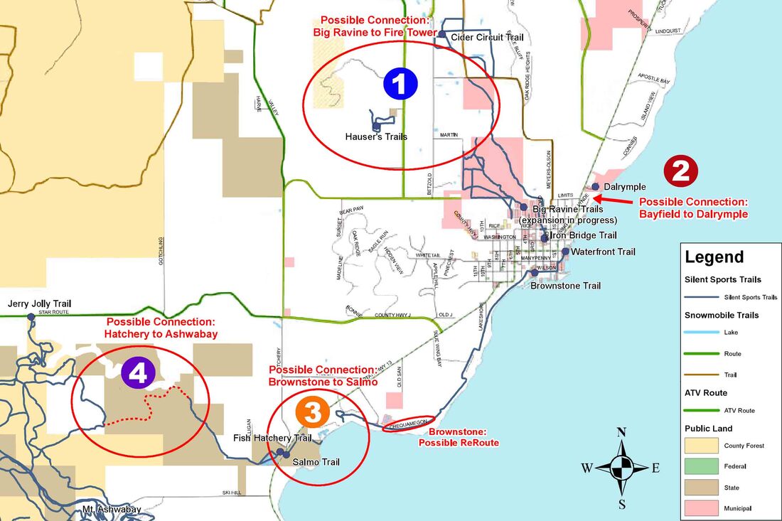
​​​​​Fire Tower Hill & Bayfield Hill Orchard Connections: We envision developing trail connections from the Big Ravine Preserve trail network to the orchards on Betzold Road and County J. This could create exciting opportunities for multi-mile loops, starting from the City of Bayfield and spending a day of walking up through the Big Ravine, visiting orchards, and exploring the newly acquired County lands on Fire Tower Hill. Developing these trails will require working cooperatively with willing landowners to establish public trail easements while respecting their private property. If this vision comes to fruition, one could hike as much as a 12-mile loop through the course of a day.​

Picture
​​​​Bayfield to Dalrymple: We envision a foot trail connecting from the lake access area at the end of Washington Ave. in the City of Bayfield along the lakeshore to Dalrymple Campground. This .5-mile trail was identified as a priority in the City’s Waterfront Plan in 2003. Not only would this add a pleasant walking trail in a natural setting in the City, but more importantly, it would enable campers to walk into the City without having to use the road shoulder on busy Highway 13. This trail would traverse very steep and thickly vegetated hillside for much of its route, posing substantial challenges to layout and construction. Additionally, trail easements need to be established across private property in cooperative manner. Therefore, we propose starting first with a short 600-foot segment that could be easily constructed from the edge of the beach to a series of rocky points along the lakeshore. Even this short segment would provide a nice walk and views of the Lake for citizens and visitors. ​

Picture
​​​​Pike’s Bay to Salmo: This trail connection depends upon the restoration of the Brownstone Trail. The vision for this section would be to connect the Brownstone Trail to the Pike’s Creek Fish Hatchery via the Salmo Trail. It would require significant cooperation with private landowners at Pike’s Bay and Port Superior.

Picture
​​Pike's Creek Fish Hatchery to Mt. Ashwabay: This potential foot trail would connect from the existing trail at the Pike’s Creek Fish Hatchery on Highway 13 to the Jolly Loop Trail at Mount Ashwabay. It would travel about 1.5 miles across Department of Natural Resources land along Pike’s Creek and then climb into the forested benches above the creek. It would provide an exciting connection that could be enjoyed throughout the year by hikers, fishermen, bird watchers, skiers, and snowshoers. ​​
Picture Bayfield Area Trails logo
Button Facebook Logo
Button Email Icon

    Comments, suggestions, great experiences? Talk to us!
    ​ 

Submit

TJoseph Media © Copyright 2023-25 Bayfield Area Trails. All Rights Reserved.
  • HOME
  • TRAILS
  • PROJECTS
  • ABOUT
  • NEWS
  • BLOG
  • PARTICIPATE