Picture

BLOG

  Best Hiking in Bayfield!
  • HOME
  • TRAILS
  • PROJECTS
  • ABOUT
  • NEWS
  • BLOG
  • PARTICIPATE

Exciting Land Donation on the Big Ravine’s East Rim Trail

7/30/2022

0 Comments

 
Plaque on bench in memory of Jan T. Larson
Plaque on trail bench in memory of Jan T. Larson. Click to enlarge image.
Map showing the Big Ravine corridor.
Map showing the location of the Larson land donation. Click image to enlarge.
​Public access along the Big Ravine’s East Rim Trail is now more secure for future generations thanks to a generous gift from Emeline Larson. Four lots encompassing almost one-half of an acre were donated by Mrs. Larson to the City of Bayfield in honor of her late husband Jan T. Larson. Since the land is within the City’s Conservancy District, allowable land uses will remain very limited in order to maintain naturalness and protect the watershed.

“We both loved how this property was perched on the edge. The views into the ravine and over the lake were always inspiring. I know that Jan would be happy to know that this special place will be forever protected and enjoyed by hikers.” A memorial bench has been placed on the property so that people can enjoy the views that the Larson’s loved. 
Bench along a trail in the forest.
A memorial bench has been placed on the property so that people can enjoy the views that the Larson’s loved. Click image to enlarge.
This donation was facilitated by the City’s Parks and Recreation Committee in order to establish long-term public access on the East Rim Trail, which has quickly become a cherished walking experience for the Bayfield area community. One Bayfield resident said “This trail has changed our lives. We walk there almost every day and never get tired of it.”

“We are incredibly grateful for this donation. Mrs. Larson’s generosity leaves a positive and long-lasting legacy, and we hope that others will consider following her example,” said Kate Kitchell, City Parks and Recreation Committee Chair.

Thanks also go to the City Council and staff who supported this project. 
0 Comments

The Apostle Islands Lakeshore Trail Gets a Facelift

7/30/2022

0 Comments

 
​The National Park Service is completing a two-year facelift of the Lakeshore Trail this summer that hikers will find more than cosmetic.  The trail improvements will protect natural resources, improve public safety and enhance visitor experience throughout the year.
Person walking across one of the wooden bridges on the trail
One of the new bridges crossing a ravine. Click image to enlarge.
​The mostly coastal, linear trail begins at Meyers Beach 4.5 miles east of Cornucopia, and traverses 6.2 miles easterly through forests upon the headlands above Lake Superior’s famous sea caves in the Apostle Islands National Lakeshore. Offering views of the islands and the dramatic sandstone cliffs, it is the area’s most popular trail and usage has increased dramatically in recent years.
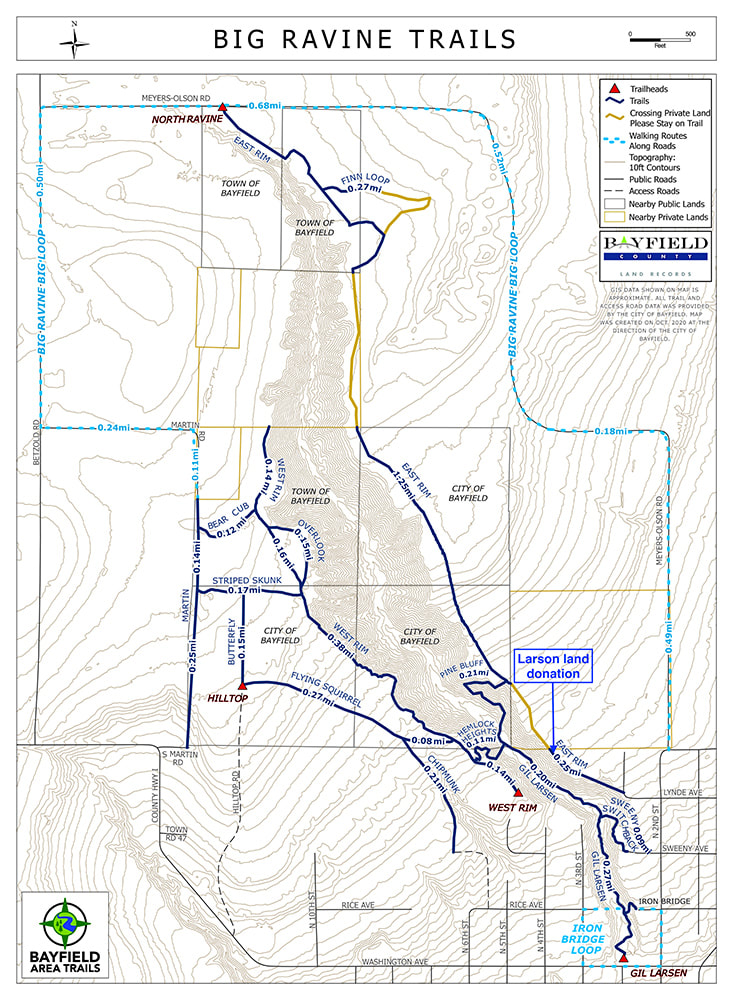
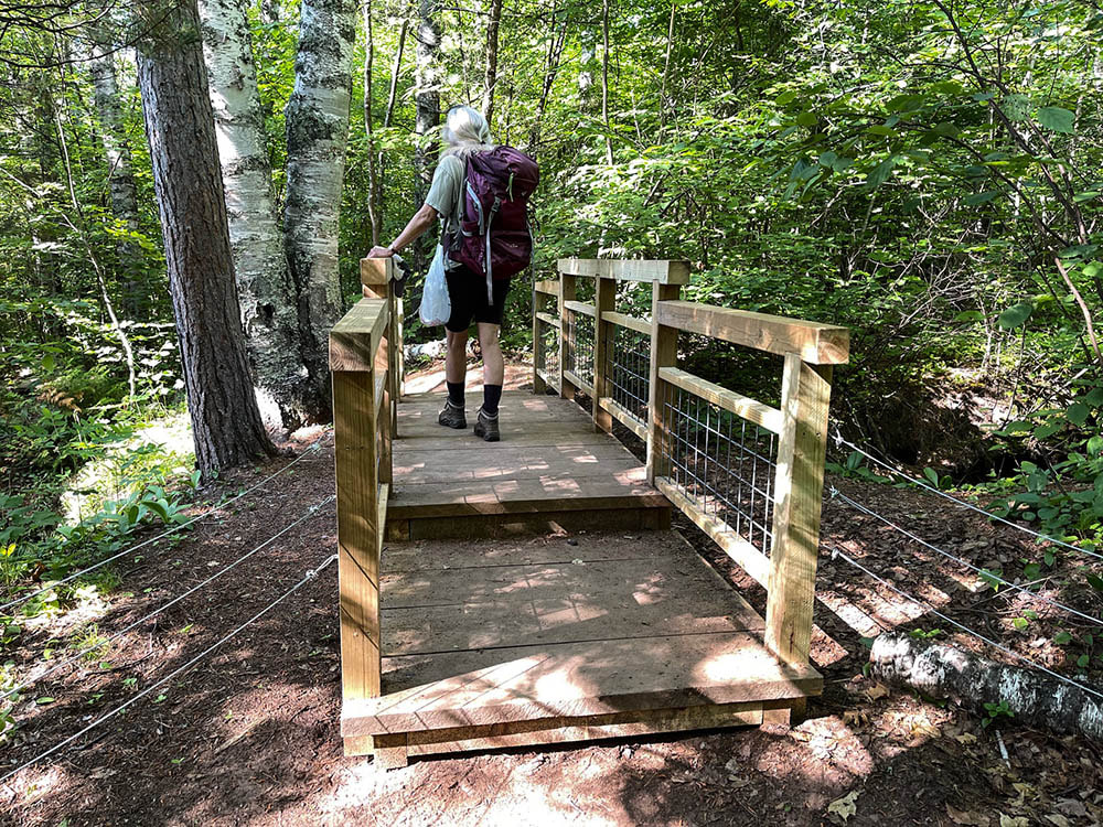
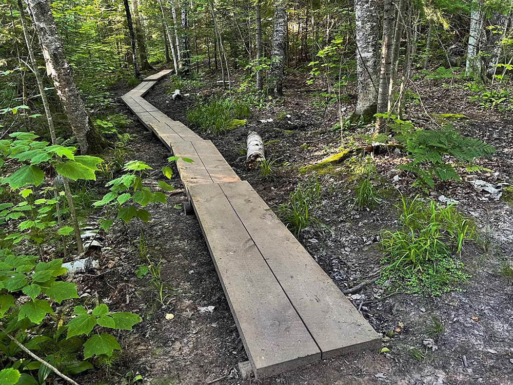
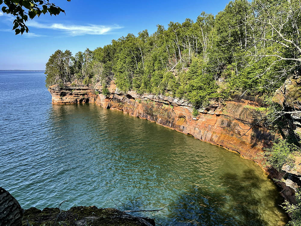
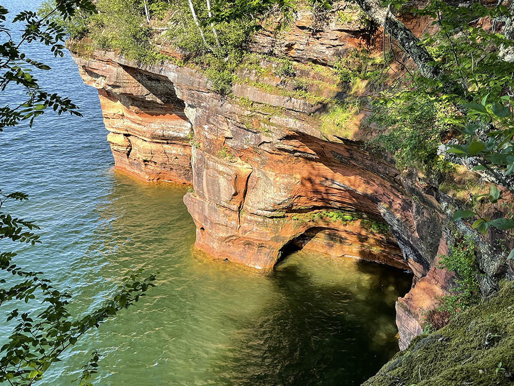
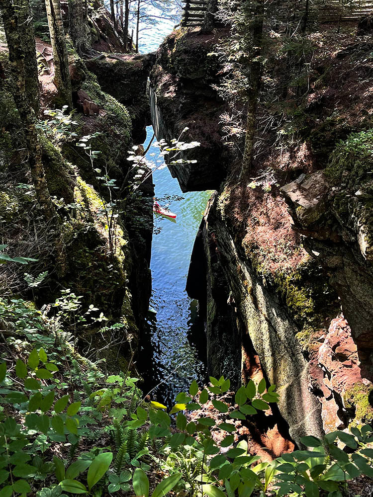
​Hikers will readily see many of the improvements. About 800 feet of new boardwalks will cover wet, muddy areas and will discourage the continuation of informal, social trails. Four new bridges spanning steep ravines, including two that are nearly 50 feet long, will replace those in poor condition and make walking easier and safer. Three beautiful, hand-crafted cedar benches will offer a respite for weary feet while five small waysides will be created for future informational and signage kiosks. And three overlooks will offer travelers great Lake Superior and island views, safely from atop the cliffs.
Click images for full-screen slideshow.
Erosion and trail damage from the old trail location
Thanks to the new trail, these impacts from past use will be able to heal.
Boardwalk through the forest
New boardwalks reduce impacts and make travel across the wet areas enjoyable.
Map from Cornucopia to Meyers Beach.
While use is limited to foot traffic only, for those who are interested in backpacking and overnight use, two new campsites will be added mid-trail, to augment the single site that now exists at the far end of the trail. 

​Some trail work will be less apparent. The trail will be rerouted in one area to prevent soil compaction around the state endangered mountain cranberry that grows here, and new water bars along the trail in spots will prevent future erosional problems. 
Click images for full-screen slideshow.
Looking across Lake Superior to an island
Several of the Apostle Islands can be seen in the distance.
View across blue water with sandstone cliffs topped by a green forest
Views of majestic cliffs along the way.
View across water with caves carved into Sandstone.
The hiker can experience fantastic views into sea caves from the trail.
View of Lake Superior through a crevasse between two sandstone cliffs
The trail gives safe access to peek through a spectacular crevasse in the cliffs.
These additions will make a great trail experience even better. Late afternoon and evening are particularly good times to enjoy the lake scenery as the western sun lights up the cliffs as the waters shimmer below. Whether you’ve hiked this trail many times, or this will be your first, you will find the walk a delight as the mix of clouds, waters and light are always creating a new  and changing palette of colors, textures and scenes to enjoy. 

For more information on the trail and current conditions, visit the Apostle Islands National Lakeshore website.
0 Comments

    Blog | Bayfield Area Trails

    VOLUNTEER & UPDATE SIGN UP

    Archives

    March 2023
    November 2022
    October 2022
    September 2022
    August 2022
    July 2022
    June 2022
    May 2022
    April 2022
    March 2022
    February 2022
    November 2021
    October 2021
    September 2021
    August 2021
    June 2021
    May 2021
    April 2021
    February 2021
    December 2020
    November 2020
    September 2020
    August 2020
    July 2020

Picture Bayfield Area Trails logo
Button Facebook Logo
Button Email Icon

    Comments, suggestions, great experiences? Talk to us!
    ​ 

Submit

TJoseph Media © Copyright 2023-25 Bayfield Area Trails. All Rights Reserved.
  • HOME
  • TRAILS
  • PROJECTS
  • ABOUT
  • NEWS
  • BLOG
  • PARTICIPATE