BLOG |
 Big Ravine Headwaters Wood Chipping Project One BAT volunteer who chipped in on our recent wood chip project was Chris Nybo, a second-grade teacher in Ventura, California! Huh? How did Chris get to be a member of the Bayfield Area Trails wheel barrow brigade? Originally from Red Wing, Minnesota, and later Duluth and the North Shore, Chris is a kayaker and a skier, and has been familiar with the Bayfield area for a long time. When he bought property here in 2005, he became a regular visitor during summer vacations from school.
“Now I’m just a part-timer in Bayfield,” Chris said, “and living and working mostly in California. But I look forward to when I can be much more than a part-time observer, and support the good stuff that’s already been happening.”
Wow! We agree with everything you said, Chris! And we especially look forward to when you’re more than a part-timer in Bayfield—ready to spread chips with another wheelbarrow brigade!!
0 Comments
 Jeff Nelson, Sue Aiken, & Mark Frazer create a water diversion. The Brownstone Trail took several hits during our major rain event on June 18-19th between Blue Wing Bay Road and the Box Steps beside Wild Rice Retreat. Shortly after the storm, Sean Reagan used his tractor and front-end loader for a great initial repair to the washed-out gullies on the steep slope that meets with Blue Wing Bay Road. Next a group of us got together to plan further repairs and water diversions for this section of trail to lower the risk of future washouts.
Mark was especially helpful and provided his ATV and trailer to haul water and equipment, so that we could better compact the gravel we had re-shaped. We built nine gradual angled diversions and filled in gullies with scavenged gravel.
Chris Nybo, who had biked to the work site, gave the diversions his mountain bike seal of approval! By the box steps, we raked displaced gravel and weeded. We worked efficiently in a couple of teams, and what we budgeted for two mornings only required one, so Saturday became a play day. The trail is looking more resilient to precipitation events. We’ll see how the area fares in the next big storm or spring runoff. Thanks, all you great volunteers! 
Standard work days will be scheduled on Friday & Saturday mornings, 9 am to noon, during the 1st, 3rd, and 5th weeks of each month:
More details on project locations & tasks will come soon; and will be posted the Monday prior via Facebook and Instagram. Come out and lend a hand!   NOTE: All images in this post can be enlarged by clicking. Bayfield Area Trails committee members, volunteers, and newcomers to the Bayfield Peninsula’s trails community, celebrated five years of Bayfield Area Trails activities! The celebration took place at the Les Voigt State Fish Hatchery, and at the Big Ravine Headwaters, during World Trails Weekend, June 1st and 2nd. The celebration included a wide range of programs, starting with early bird walks, followed by a talk on the Pikes Creek watershed, field season updates from Bayfield Area Trails committee members, highlights of volunteer opportunities, and a wrap up dedication of the new pond overlook platform and trails at the Big Ravine Headwaters. Despite the downpour, 55 trails enthusiasts attended the Saturday celebration, including 15 new volunteers.
The Best Food & Coffee!
Round Robin Field Season Reports
Here are some more of our fantastic presenters. Click images to enlarge.
Calling All Volunteers!
Launching the Bayfield Peninsula Trails PlanThe Trails Celebration marked the launch of a planning effort to develop a comprehensive, long-term, & sustainable Bayfield Peninsula trails plan and a strategy. Bayfield Area Trails Committee Chair Kate Kitchell introduced this year-long effort, calling on participants to provide their suggestions for improving existing trails. Recommendations were also requested for potential new trails. The goal is to create a Peninsula-wide silent sports trails network.
Hover/tap the image carousel below for navigation & viewing options. The plan will be supported by a technical assistance grant from the National Park Service Rivers, Trails, and Conservation Assistance (RTCA) program and a grant from the Apostle Islands Area Community Fund. BAT Committee members, stationed at tables around the tent, discussed maps and gathered ideas from attendees. This was just the beginning of the process. Community members will have more opportunities to provide input and review progress during the planning process.
There's Lots Going on at the Hatchery
Below are images from the Hatchery tour conducted by Darren Miller, Operations Supervisor of the Les Voigt and Brule Hatcheries for the Wisconsin Department of Natural Resources.
Hover/tap the image carousel below for navigation & viewing options. Wrap Up with the Big Ravine Headwaters Dedication CelebrationIn Sunday afternoon’s sunshine, a couple dozen supporters gathered at the Headwaters pond overlook platform to say thanks to all who made a dream become a reality. Erika Lang from Landmark Conservancy emceed the gathering. She gave special recognition to Ed Rabideaux for leaving a lasting legacy by selling the 10-acre parcel for conservation and public enjoyment.
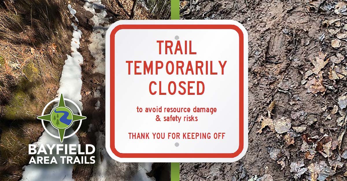
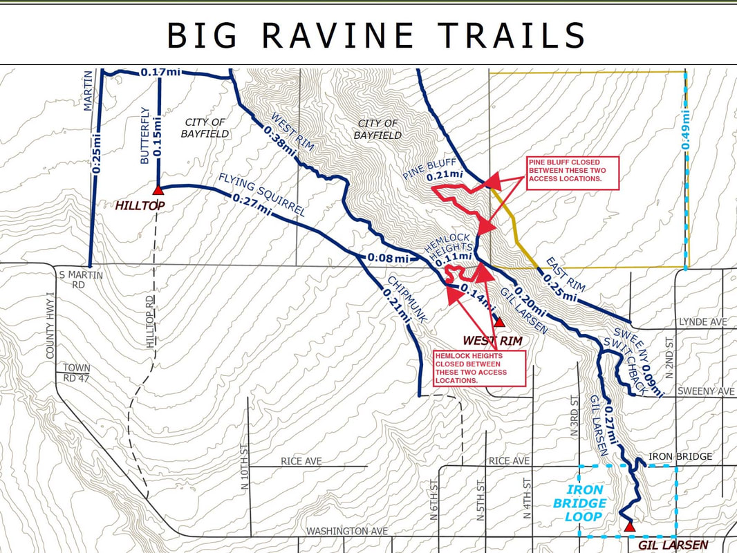
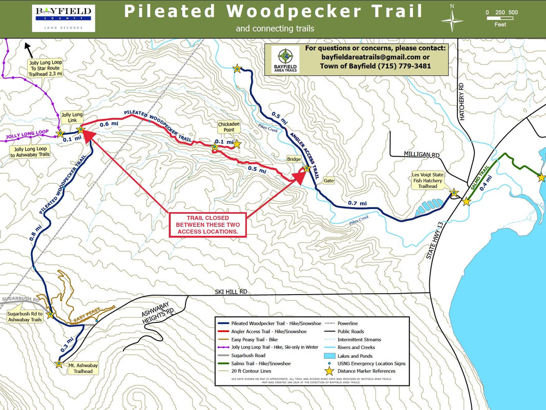
Tom Gordon, previous Town of Bayfield Board Chair, reflected on how working together with public and private partners is a fantastic way to get things done. Glenn Guntenspergen from the Biodiversity Fund, one of the grantors, reminded everyone how places like the Headwaters connect people with the natural world and inspire land stewardship. To wrap up the weekend celebration, the banner was cut to a round of cheers and applause! Hooray for all!! Hover/tap the image carousel below for navigation & viewing options. Trail Note:We originally planned to dedicate the Pileated Woodpecker trail as well. However, access from the Les Voigt Hatchery remains closed beyond the Red Dam gate.
The Wisconsin Department of Natural Resources, Bayfield County, and private landowners are working to determine property boundaries and options for re-establishing access. Thank you for respecting the closure. BUT…the trail can be accessed from Mt. Ashwabay and will be much improved after volunteers finish the corridor that was cleared last fall. Volunteer recruitment for that project will start in mid-July. Come on out and help! 
THANK YOU VOLUNTEERS!!A small army of fabulous volunteers made the 2024 Bayfield Area Trails Celebration possible!!
 Mary & Jen create a new tread.
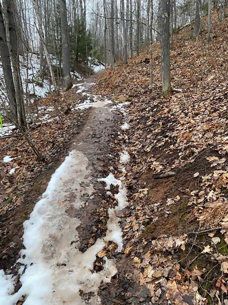
A short segment of the West Rim Trail was also re-routed to avoid a seep that had created slippery conditions and caused people to widen the trail by going around the bad spot. All of these improvements not only make the walking experience more pleasant, they also resolve drainage and erosion issues so that the trails are more sustainable and easier to maintain over time. Since these trails are on City of Bayfield property, the City Parks and Recreation Committee provided funding for boardwalk materials. Let’s give a shout out to Mike Kinnee, John Ipsen, Mary Ledin, Jen Crump, Jon Crump, Anna Stocksdale, Kate Kitchell, and Sue Aiken for racking up a total of 56 hours of volunteer time!! They also brought their own tools including mattocks, pulaskis, Rogue hoes, McLeods, circular saws, screw guns, loppers, hand saws, shovels, rakes, and sledges to the party. Mary Ledin’s multi-component battery-powered weed trimmer and brush saw was the biggest hit! So many tools to choose from! Come on out and join the fun on our next project on the Upper Pileated Woodpecker Trail in July and August. Stay tuned for details and sign up for our mailing list!  After the intense rain event on June 18th – 19h, volunteers ventured out on the trails to assess trail safety and resource condition. While all trails are passable, many areas are gullied and runoff has displaced soil or gravel and piled up debris. Please use caution when crossing deep gullies such as on the Brownstone Trail at Blue Wing Bay Road, as the sides could collapse. There is standing water or heavy mud where drainage is minimal, including on the Big Ravine’s Headwaters and upper East Rim; Brownstone Trail near the Wild Rice Retreat; and Jerry Jay Jolly. Practice muddy trail etiquette: if you leave a track, please turn back. Or, if you feel compelled to walk the trail, walk through the mud, not around it. From what we see, all of the issues can be repaired, but we’ll need lots of volunteers to help during the next 2-3 months, especially on the Brownstone, Big Ravine, and Siskiwit River Preserve.
 Big Ravine Headwaters Boardwalk. Fourteen Bayfield Area Trails volunteers slogged through the mud at the Big Ravine Headwaters and navigated through fallen trees at Frog Bay Tribal National Park to ready trails for use this season.
 Enjoying a break on the beach at Frog Bay. Spring was bursting forth in the Frog Bay TNP woods, with the sights and sounds of Black-throated Blue Warblers, Magnolia Warblers, Ovenbirds, Northern Parulas, Black-throated Green Warblers, Black & White Warblers, Hermit Thrushes, Black-capped Chickadees and others.
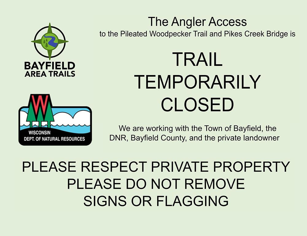
Please join us as a volunteer: keep your eyes peeled for a call for volunteers for the next project scheduled for June 6th – 9th on the Big Ravine’s Flying Squirrel and West Rim Trails. 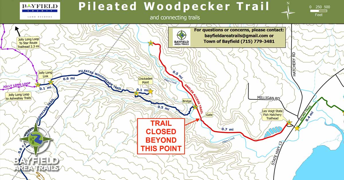 The Angler Access Trail beyond the Red Dam gate upstream from the Les Voigt State Fish Hatchery is temporarily closed. This Trail provides access to the new bridge across Pikes Creek and the Pileated Woodpecker Trail. A recently completed official survey by Bayfield County found that a portion of the Angler Access Trail is under private ownership, not under the ownership of the Wisconsin Department of Natural Resources (DNR). As a result, there is currently no legal public access between the Red Dam gate and the new bridge.
Anyone traveling on private property without permission would be considered in trespass. PLEASE do not remove signs, survey stakes, or flagging. As discussions move forward we will post new information on the website and Facebook page as it becomes available.
THANK YOU FOR YOUR SUPPORT! 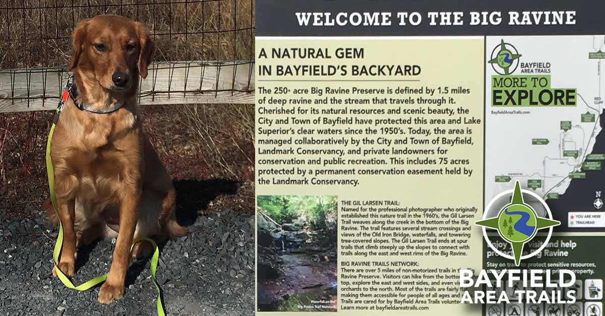 Bayfield dog Holly recently visited the Big Ravine and took note of the sign—especially the images pertaining to dogs. “My human brought my leash!” Holly says. “Remember to bring yours!”
As the spring and summer hiking seasons approach, Bayfield Area Trails (BAT) reminds trail-users that we strive to provide a safe and high-quality experience for everyone. To that end, hikers with dogs are asked to behave responsibly, keeping dogs under control at all times, and properly disposing of their waste.
Due to their steep slopes, sensitive soil types, and narrow trail corridors with multiple switchbacks, these trails are especially prone to severe damage when muddy.
THANK YOU FOR HELPING TO KEEP OUR TRAILS IN GREAT SHAPE!
|